Tocht Stappen The Municipal District of Wicklow - Knocknacloghoge and Fancy Mtn - Photo
 jaf299
jaf299

Gebruiker

© OpenStreetMap contributors
Lengte
Lengte
13,1 km
Max. hoogte
Max. hoogte
590 m
Positief hoogteverschil
673 m
Km-Effort
Km-Effort  
22 km
Min. hoogte
Min. hoogte
208 m
Negatief hoogteverschil
672 m
Boucle
Boucle
Ja
Datum van aanmaak :
2014-12-10 00:00:00.0
Laatste wijziging :
2014-12-10 00:00:00.0

(0 Bericht)

Stappen
Stappen
--
Moeilijkheid : Onbekend

Scan deze QR-code om de tocht te openen in de SityTrail-applicatie

Gratisgps-wandelapplicatie

Logo SityTrail SityTrail

IGN / Geografische instituten

SityTrail uit de App Store downloaden SityTrail uit Google Play downloaden

Logo SityTrail SityTrail World

De wereld gaat voor u open

SityTrail uit de App Store downloaden SityTrail uit Google Play downloaden SityTrail op Huawei AppGallery downloaden

Over ons

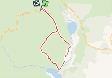
Tocht Stappen van 13,1 km beschikbaar op Onbekend, County Wicklow, The Municipal District of Wicklow. Deze tocht wordt voorgesteld door jaf299.

Hoogteprofiel

Plaatsbepaling

Land:
Ireland
Regio :
Onbekend
Departement/Provincie :
County Wicklow
Gemeente :
The Municipal District of Wicklow
Locatie:
Glendalough
Vertrek:(Dec)
Vertrek:(UTM)
680568 ; 5888750 (29U) N.

Wandeltochten in de omgeving

Tocht Te voet Onbekend - The Sugar Loaf Way - Photo
Te voet
GUIDE+

Te voet

Gemakkelijk
Onbekend, Onbekend, Onbekend, Ireland
4,5 km | 7,6 km-effort
1h 43min
Neen
Tocht Te voet The Municipal District of Arklow - Avonmore Way - Photo
Te voet
GUIDE+

Te voet

Gemakkelijk
The Municipal District of Arklow, Onbekend, County Wicklow, Ireland
12,9 km | 17 km-effort
3h 51min
Neen
Tocht Te voet Onbekend - De Buitléar Way - Photo
Te voet
GUIDE+

Te voet

Gemakkelijk
Onbekend, Onbekend, Onbekend, Ireland
4 km | 6,1 km-effort
1h 23min
Ja
Tocht Te voet The Municipal District of Wicklow - Spinc and Glenealo Valley - Photo
Te voet
GUIDE+

Te voet

Gemakkelijk
The Municipal District of Wicklow, Onbekend, County Wicklow, Ireland
9,2 km | 14,6 km-effort
3h 19min
Ja
Tocht Te voet The Municipal District of Wicklow - Slí na Sláinte - Photo
Te voet
GUIDE+

Te voet

Gemakkelijk
The Municipal District of Wicklow, Onbekend, County Wicklow, Ireland
7,1 km | 7,8 km-effort
1h 46min
Ja
Tocht Te voet The Municipal District of Wicklow - Saint Kevin's Way - Photo
Te voet
GUIDE+

Te voet

Gemakkelijk
The Municipal District of Wicklow, Onbekend, County Wicklow, Ireland
6,6 km | 10,2 km-effort
2h 19min
Neen
Tocht Te voet The Municipal District of Baltinglass - Blessington Greenway - Photo
Te voet
GUIDE+

Te voet

Gemakkelijk
The Municipal District of Baltinglass, Onbekend, County Wicklow, Ireland
6,8 km | 7,8 km-effort
1h 46min
Neen
Tocht Te voet Onbekend - Bray Greystones Cliff Walk - Photo
Te voet
GUIDE+

Te voet

Gemakkelijk
Onbekend, Onbekend, Onbekend, Ireland
5,8 km | 7,2 km-effort
1h 38min
Neen
Tocht Te voet The Municipal District of Greystones - Delgany Heritage Trail - Photo
Te voet
GUIDE+

Te voet

Gemakkelijk
The Municipal District of Greystones, Onbekend, County Wicklow, Ireland
4,6 km | 6,1 km-effort
1h 22min
Ja


Sluiten
Mijn abonnementen